Surveying has been around for centuries, and the basic process hasn’t changed much. A surveyor goes out into the field, measures angles and distances, and uses that data to produce a map or blueprint of the area. But what has changed is how that data is collected and processed. How is Traditional Surveying Data Integrated With Computer Technology? You’ll get here details about the topics.
Traditional surveying methods relied on manual measurements with instruments like transit levels and tape measures. Today, those instruments are still used, but the data they collect is fed into computer software that can quickly generate highly accurate maps. This computer-aided surveying (CAS) technology has revolutionized the field by increasing efficiency and accuracy while reducing costs.
In the past, surveying data was collected using traditional methods such as measuring tape and level. This data was then transferred onto paper maps or drawings. With the advancement of computer technology, surveying data can now be collected using GPS (Global Positioning System) and GIS (Geographic Information System).
How is Traditional Surveying Data Integrated With Computer Technology?
GPS is a satellite-based navigation system that can provide accurate location information. This information can be used to create digital maps or models of the land surface. GPS is often used in conjunction with GIS to create more accurate and detailed maps.
GIS is a system that captures, stores, manipulates, analyzes, and displays geographic data. GIS can be used to create digital maps as well as 3D models of the land surface. It can also be used to analyze data such as population density or soil type.
Traditional surveying methods are still used in some cases, but the use of GPS and GIS has become more widespread in recent years. The integration of these two technologies has allowed for more accurate and detailed surveys to be conducted.

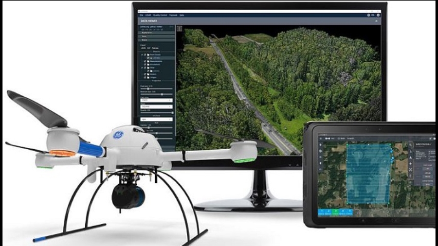
Credit: www.microdrones.com
How Does Traditional Surveying Data Get Integrated With Computer Technology
The traditional surveying process has been around for centuries and relies on very precise measurements using specialized equipment. Over the years, this process has become increasingly more accurate as technology has improved. Today, traditional surveying data can be integrated with computer technology to create even more accurate results.
There are a few different ways that traditional surveying data can be integrated with computer technology. One way is by using GPS (Global Positioning System) receivers. GPS receivers can be used to take very precise measurements of an area.
This data can then be fed into a computer program which can generate a map of the area that is being surveyed. Another way that traditional surveying data can be integrated with computer technology is by using lasers. Lasers can be used to take extremely precise measurements of an area.
Do you know Which of the Following is a Computer-Related Mistake? Don’t worry stay here and read details.
Drone Data Processing for Surveyors
This data can then be fed into a computer program which can generate a 3D model of the area that is being surveyed. Traditional surveying methods are still widely used today, but by integrating these methods with modern computer technology, surveyors can create even more accurate results.
Why Do Computer Mapmakers Digitize Map Data?
Computer mapmakers use a process called digitizing to create digital maps from paper or other analog sources. This process involves tracing the contours of features on a map and converting them into coordinates that can be stored in a computer. Digitizing is the only way to create digital maps that are accurate enough to be used for navigation or other purposes.
There are several reasons why computer mapmakers might choose to digitize map data. One reason is that it allows them to improve the accuracy of the data. Another reason is that digitizing makes it possible to add additional information to the map, such as labels or street names.
Finally, digitizing makes it easier to share maps with others, since they can be transmitted electronically instead of physically mailed.
How Do Traditional Methods of Mapmaking Differ from Current Methods?
There are two main ways to create a map: traditional methods and modern methods. Traditional methods involve using a variety of tools to physically draw out the map, while modern methods make use of computers and software to create digital maps.
Traditional mapmaking is a painstaking process that can take weeks or even months to complete.
cartographers must first gather accurate information about the area they wish to map. They then use this information to create a detailed sketch of the area, which is often done by hand. Once the sketch is complete, it must be transferred onto another medium, such as vellum or paper.
Finally, all of the features on the map must be carefully drawn in, including mountains, rivers, roads, and towns.
Modern mapmaking is a much quicker process thanks to advances in technology. Computers can now store large amounts of data, making it easy for cartographers to access the information they need.
In addition, software programs can be used to automatically generate many of the features found on a map, such as terrain and elevation data. As a result, it’s now possible to create a high-quality map in just a few hours or days.
Surveying Technology Degree
As the demand for surveying services increases, so does the need for qualified surveyors. A Surveying Technology degree can provide you with the skills and knowledge necessary to become a successful surveyor.
The first step in becoming a surveyor is to obtain a high school diploma or equivalent.
Once you have your diploma, you will need to complete an accredited surveying program. There are many different types of surveying programs available, so it is important that you choose one that best suits your needs. After completing your surveying program, you will need to pass the National Council of Examiners for Engineering and Surveying (NCEES) Principles and Practice of Surveying (PS) Exam.
Once you have passed the PS Exam, you will be eligible to become licensed as a Professional Surveyor (PS). In order to maintain your license, you will need to complete continuing education credits each year.
New Technology in Land Surveying
New technology in land surveying has revolutionized the way that surveys are conducted. In the past, land surveys were conducted using traditional methods such as measuring tapes and level rods. These methods are still used today, but new technology has made the process much easier and more accurate.
One of the most popular new technologies is GPS (Global Positioning System). GPS receivers can be used to determine the exact location of a point on the earth’s surface. This information can then be transferred to a computer which will generate a map of the area.
GPS is especially useful for large tracts of land or for surveying in remote areas where there are no landmarks.
Another new technology that is being used in land surveying is LiDAR (Light Detection and Ranging). LiDAR uses laser pulses to create a three-dimensional map of an area.
This technology can be used to survey large areas very quickly and with great accuracy.
The use of new technology in land surveying has made it possible to survey larger areas in less time with greater accuracy than ever before.
New Technology Surveying Equipment
If you’re in the surveying business, then you know that new technology has changed the game when it comes to equipment. There are now a variety of new surveying instruments available on the market, each with its own unique set of features and benefits. In this blog post, we’ll take a look at some of the latest and greatest surveying equipment out there so that you can make an informed decision about which one is right for your business.
One of the newest pieces of surveying equipment is the GNSS Receiver. This instrument uses satellite technology to provide highly accurate measurements for both horizontal and vertical positioning. GNSS receivers are ideal for large-scale surveys where precision is paramount.
Another option is laser scanning equipment. This type of instrument uses lasers to create 3D models of objects or terrain. Laser scanning is perfect for surveys that require detailed mapping, such as topographical surveys or archaeological surveys.
If you need to survey an area that doesn’t have a clear line of sight (such as a forest), then UAV (unmanned aerial vehicle) Surveying Equipment is what you need. UAVs are equipped with high-resolution cameras and sensors that allow them to capture data from hard-to-reach places.
What is a Pixel And How Does It Relate to Map Making?
When it comes to understanding pixels, it’s important to know that a pixel is simply a point on a map. The term pixel originates from the computer world and stands for “picture element.” Pixels are the smallest building blocks of an image, whether it’s a raster graphic or a digital photo.
When you zoom in on an image, you can see the individual pixels that make up that image. Pixels are important when it comes to map making because they dictate the level of detail that can be included in a map. The more pixels there are, the more detailed the map can be.
For example, if you’re creating a map of your backyard, you wouldn’t need as many pixels as you would if you were creating a map of your city. There are two types of maps: vector and raster. Vector maps are made up of points, lines, and polygons (areas), while raster maps are made up of pixels.
Vector maps can be edited easily because each element is separate from the others. Raster maps cannot be edited as easily because all the pixels are connected to each other. However, raster maps can show more detail than vector maps because they have more resolution (pixels).
There are other resources that may help you to know on How Old is My Computer in Human Years? Why Did the Computer Go to the Doctor? and Which Innovation Helped to Make Computers More Powerful?
Satellite Images are Based on Data Obtained by ____________ (Gps/Landsat) Satellites.
Satellite images are a great tool for observing and understanding the Earth’s surface. They are based on data obtained by GPS or Landsat satellites. GPS satellites orbit the Earth at a height of about 20,000 km, while Landsat satellites orbit at a height of about 780 km.
GPS satellites use radio waves to triangulate their position relative to ground stations on Earth. This information is then used to calculate the satellite’s location and velocity. The data from GPS satellites is very accurate, but it can only be used to observe large areas of the Earth’s surface.
Landsat satellites use visible and infrared light to image the Earth’s surface. This data can be used to create detailed maps of the land surface. The resolution of Landsat images is much higher than that of GPS images, but they can only be used to observe small areas of the Earth’s surface.
What Technology is Going on That Allows the Total Station to Take Measurements
If you work in the surveying or construction industry, chances are you’ve heard of a total station. But what exactly is a total station? And what technology is going on that allows it to take measurements?
A total station is an electronic/optical instrument used for surveying and construction. It’s basically a theodolite (a tool used for measuring angles) combined with an electronic distance meter. This combination allows the total station to take accurate measurements of both horizontal and vertical angles, as well as distances.
So how does the total station actually work? Well, it uses a number of different technologies, including EDM (electronic distance measurement), optical leveling, and GPS (global positioning system).
EDM works by sending out a pulse of infrared light towards the target object.
The time it takes for the light to bounce back is then measured, and this information is used to calculate the distance between the total station and the object.
Optical leveling works by using a telescope to sight both the horizon and the target object. The difference in elevation between these two points is then calculated, giving you the vertical angle measurement.
GPS provides accurate location data for thetotal station. This data is then used in conjunction with EDM and optical leveling measurements to provide even more accurate results.
Final Note
Surveying has come a long way since its humble beginnings. The process of surveying land, collecting data, and creating maps was once a time-consuming and labor-intensive task. But with the advent of computer technology, surveying has become much more efficient.
Today, surveyors use computers to collect data and create maps. Computer-aided design (CAD) software is used to create accurate drawings of land features. GPS systems are used to pinpoint the exact location of points on the earth’s surface. I expected that you’ve get details on How is Traditional Surveying Data Integrated With Computer Technology.
And laser scanning technology is used to create detailed 3D models of terrain. All of this data can be stored in a digital format and shared with others easily. This makes it possible for architects, engineers, and planners to collaborate on projects from anywhere in the world.